
Xizang (Tibet) Was not A Part of China Before 1950s? Shut up!
Western media oftern say that Xizang was not a part of China before Chinese Communists liberated the brutal serf society ( How brutal it was? come here. )and kicked out the serf owner Dalai Lama.
Here are some maps that were printed by other countries before Chinese Communists took the power in China. China was weak then and could not force US, Germany, and India to print out those maps, right?
Keep this in mind: Xizang was China's Xizang, is China's Xizang and will be China's Xizang forever!

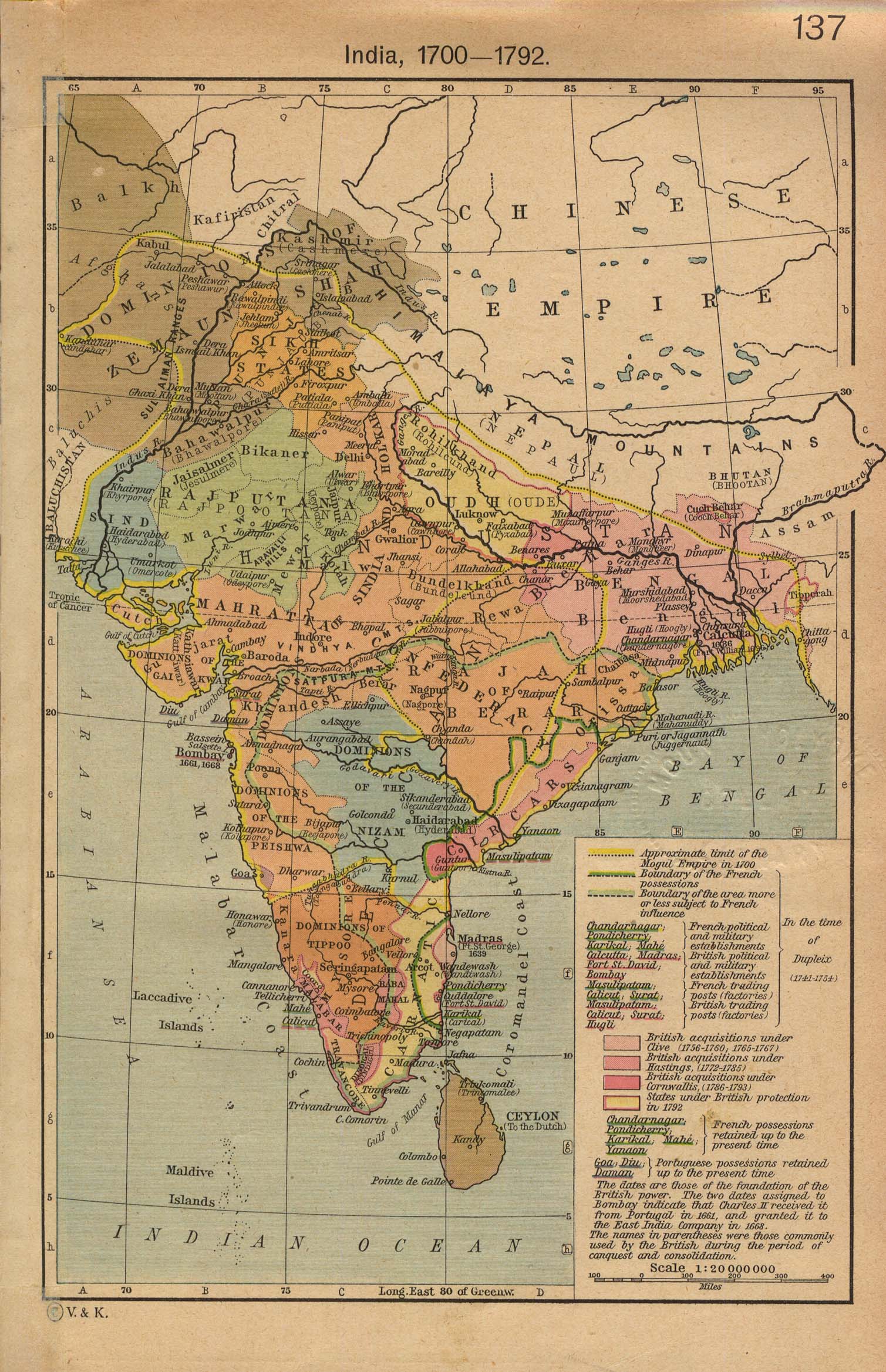
This map was printed in India. It shows the Sino-India border between 1700-1792 as stated on the map. Xizang was a part of Chinese Empire. This map is from The Historical Atlas by William R. Shepherd, 1923. You can find it here.

This is a map printed by Germany in 1891. It reflects China's territory before 1891. Germans, open your eyes, and then tell me: wasn't Xizang not in China back then? The same map can be found here. It was published by Gotha:Julius Perthes in 1891.

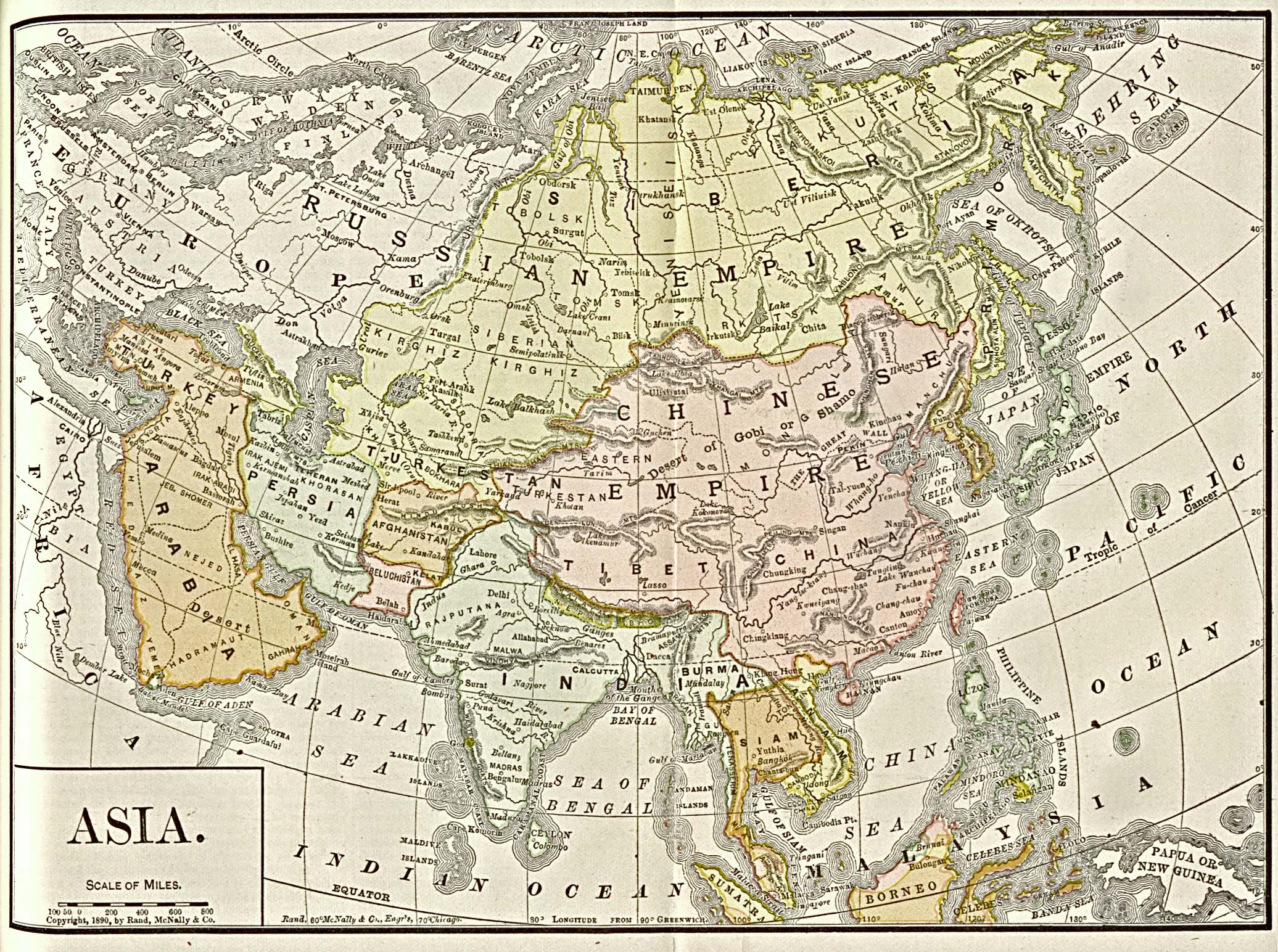
This is a map published before 1900. That's definitely not a map printed by China. Was Xizang in China? It was from Americanized Encyclopaedia Britannica, Vol.1, Chicago 1892. You can find it here.

A map published in US in 1900. Xizang isn't a part of China?
Thanks the reader who provided this map in his comment.

This is a world map printed by US in 1942. That's before Chinese Communists took power in China. Didn't Xizang belong to China?
Here are some maps that were printed by other countries before Chinese Communists took the power in China. China was weak then and could not force US, Germany, and India to print out those maps, right?
Keep this in mind: Xizang was China's Xizang, is China's Xizang and will be China's Xizang forever!

This map was printed in India. It shows the Sino-India border between 1700-1792 as stated on the map. Xizang was a part of Chinese Empire. This map is from The Historical Atlas by William R. Shepherd, 1923. You can find it here.

This is a map printed by Germany in 1891. It reflects China's territory before 1891. Germans, open your eyes, and then tell me: wasn't Xizang not in China back then? The same map can be found here. It was published by Gotha:Julius Perthes in 1891.
This is a map published before 1900. That's definitely not a map printed by China. Was Xizang in China? It was from Americanized Encyclopaedia Britannica, Vol.1, Chicago 1892. You can find it here.
A map published in US in 1900. Xizang isn't a part of China?
Thanks the reader who provided this map in his comment.

This is a world map printed by US in 1942. That's before Chinese Communists took power in China. Didn't Xizang belong to China?
posted by NewsChecker | 7:21 AM
![]()
38 Comments:
hi,
I just upload an old 1900's map that pubished in us, think maybe you can use. here is the link: http://www.pbase.com/jas321/image/94292450
That is very informative.
Should show these maps to TV news editors and newspaper editors.
I always hear the story about Tibet by starting with " the 1951 Chinese invasion...."
The last one is an outline of post-war new world map. You'd better remove it, since in that map China contains Korea and Vietnam, which is absurd.
description about the second last map you may put on:
Map of China, Burma, Siam, Annam &c
Author: Bacon, G. W. (George Washington)
Publisher: G.W. Bacon & Co.
Date: 1900
Dimensions: 74 x 75 cm
Scale: Scale not given
I agree that the last one should be removed, for it's not a real map.
The last one from US congress library and was printed in 1942. That's a good one since westerners say Tibet was not a part of China before Communist party took the power in 1949. I think it's ok to use it.
Not that any of this is particularly relevant - of a majority wants to go, they should be allowed to go.
So spake the Quebecer.
Hi, You did a great job here. Could you please contact me via the email mullet.forever at gmail.com? I have some more information and suggestions for you.
To filer:
The point is show that Tibet is part of China, and it didn't start in 1951.
love the maps.
people are going to freak out when they find out the world actually IS FLAT.
Ya know.. Japan OWNS Hawaii's real estate and Mexico owns Los Angeles sweat shops now.
just so you know
The third one was published in US in 1890. That publisher called Rand McNally company. Founded in 1856 and headquartered in Skokie, IL, just outside of Chicago. And now they're in more than 60,000 retail outlets and distribute to 98% of schools across the U.S.
www.kimsoft.com/2003/us-kr-relation.htm
www.kimsoft.com/2003/kr-map-old.jpg
-----
http://images.google.com/images?sourceid=navclient&ie=UTF-8&rlz=1T5GGLL_enCN262CN262&q=china+map+qing&um=1&sa=N&tab=wi
http://map.huhai.net/62-63.jpg
http://map.huhai.net/58-59.jpg
http://kcjun.5d6d.com/thread-1011-1-1.html
thank you so much for the information. As a Chinese student in US, I wanna collect some info like this for my research and anti"free Tibet"club in our school!
-- You'd better remove [the last map], since in that map China contains Korea and Vietnam, which is absurd.
Actually, not so absurd. China has a better historic claim over Vietnam than it does over Tibet. It ruled the country for one thousand years.
Also, does China claim Mongolia as part of its territory forever? The Qing empire directly ruled over Mongolia (Incidentally unlike Tibet, except for a short period). This is shown in the maps.
Other maps from the period on the other hand don't include Tibet as part of China.
Good set of maps! It shows not only Tibet, but also other souvereign countries (Mongolia, countries of SE Asia etc.) as parts of China. Good evidence that Tibet should be free!
Had your old man *!@$ your mom 150 year ago and got you out, your wet dream would have more chance to be fulfilled. What a pitty!
"Forever" does not exist.
See my YouTube film
"Hey! HeY! We're The Humans" which features both Chairman Mao and The Dali Lama.
So your last map was from 1942. And you will see: West- an East-Germany belongs to the USSR-protectorate. Do you think, that was true? I think you last map only shows, that the USA thought that could be, if they don´t enter the II. world war. So werre are the maps 1910-1940?
On March 15, 2007, FDA learned that certain pet foods were sickening and killing cats and dogs. FDA found contaminants in vegetable proteins imported into the United States from China and used as ingredients in pet food.
A portion of the tainted pet food was used to produce farm animal feed and fish feed. FDA and the U.S. Department of Agriculture discovered that some animals that ate the tainted feed had been processed into human food. Government scientists have determined that there is very low risk to human health from consuming food from animals that ate tainted feed. All tainted pet food, animal and fish feed, and vegetable proteins continue to be recalled and destroyed.
As a result of FDA and USDA's comprehensive investigation, on February 6, 2008, FDA announced that two Chinese nationals and the businesses they operate, along with a U.S. company and its president and chief executive officer, were indicted by a federal grand jury for their roles in a scheme to import products purported to be wheat gluten into the United States that were contaminated with melamine.
Good work! Keep up!!
Sure. But what about in the Ming? The Ming government had no influence in Tibet. Nor did the governments of the Song, Tang, Sui, Han, or Qin. (Sure, Tang princesses married Tibetan kings, but marriage alliances are not the same as political integration.) Heck, a Tibetan army invaded and burned Chang'an (today's Xi'an, at that point the national capital) during the Tang.
You are correct in saying that the claim Tibet was not a part of China before 1951 is silly. But it's just as silly to say Tibet has never been an independent country.
And it's worth noting that, until 1951, Tibet was never ruled by Hans; neither the Qing nor the Yuan was Han-controlled, and those were the only two dynasties that had control in Tibet.
Keep attention on the sources: 1942 map is a outline of the new world order as imagined in '42, so is just a projection, without any documental value... I'm sure you'll be able to find lots of maps showing the same without showing that ridiculous one...
Job well done !!
But I would like to call everyone's attention that ALL members of UN(i.e. the whole world) including US, France, Germany,UK, India, Japan ....etc. recognize OFFICIALLY that XiZang(Tibet) is part of China, I have
yet to know even 1 country says otherwise.
Can someone tell me one?
Kangxi a Manching ethnic minority and Emperor of China personally consolidated the Chinese empire on behalf of China.
Unfortunately news checker, it doesn't matter how many irrelevant posts you make on a blog, I won't shut up!
Produce as many maps as you like, but these maps were produced, according to you, in India, Germany and the USA...none were from Tibet!
So if you are looking at the status of Tibet, surely you should look to the actual place and see what was happening.
That was, that the Tibetans expelled all Chinese officials in 1913 and looked after their own afairs until 1950. The Chinese republican government exercised absolutely no control over the Tibetan administration.
That seem more relevant to the actual situation than a map made by someone who had never been to Tibet!
chinese tea consists of tea leaves which have been processed using methods inherited from China. According to popular legend, tea was discovered by Chinese Emperor Shennong (Shen Nung, Shen Nong, The Yan Emperor, The Emperor of the five grains) in 2737 BC when a leaf from a Camilla sinensis tree fell into water the emperor was boiling. Not everyone agrees on the origin, but no one disputes that tea is deeply woven into the history and culture of China. The beverage is considered one of the seven necessities of Chinese life, along with firewood, rice, oil, salt, sauce and vinegar.
Some writers classify tea into four categories, white, green, oolong and black. Others add categories for red, scented and compressed teas. All of these come from varieties of the Camilla sinensis plant. Chinese oolong tea, while popular, is not a true tea. Most Chinese tea is consumed in China and is not exported. green tea is the most popular type of tea used in China.
If Tibet belongs to the Chinese before the 1950s and we all know that China used to belong to the Qing Dynasty, then it has nothing to do with the Chinese Communist.
It belongs to the Qing Emperor, but since the Qing Emperor is no more, Tibet does not belong to China.
That's it.
If you want to argue, please grow your Pig Tail...
When the Buddha was a little kid, he took care of a swan. One day his cousin shot down the swan and both argue to get the swan.
Unable to settle the dispute, both of them went to the wise man.
The wise man says, the swan belongs to the one who takes care of the it, not to one who destroy it.
So who does Tibet belong to?
The Buddha had already told us the story...
(the one who would take good care of it).
It's the same when the parents fight for custody of the kid...
So China, dun be a nasty parent, you might lose the custody...
Today, the Microsoft-owned in-game ad agency said that it has signed an exclusive multiyear agreement with Blizzard. Azerothians opposed to seeing in-game ads in their local world of warcft gold watering holes need not worry, however, because the deal is limited to Blizzard's Web sites and Battle.net,the game maker's online-gaming hub. Terms of the deal were not announced, but Massive did note that the agreement is applicable to users in the US, Canada, Europe, South Korea, and Australia.
buy wow gold
Massive also said today that it would be extending its aforementioned deal with Activision to encompass an additional 18 games appearing on the Xbox 360 and PC.cheap wow goldThe agency didn't fully delineate which would fall under this deal, though it did call out Guitar Hero: World Tour, James Bond: Quantum of Solace, and Transformers: Revenge of the Fallen,buy wow items as well as games in its Tony Hawk and AMAX Racing franchises.Shortly before Activision and Vivendi announced their deal of the decade,wow power leveling the Guitar Hero publisher signed on to receive in-game advertisements from Massive Inc for a number of its Xbox 360 and PC games. A bit more than a year later, Massive is now extending its reach to Activision's new power player, Blizzard Entertainment.buy wow gold from our site ,you'll get more surprises
Western media's always biased... anyone with half a brain should know that.
anyone with half a brain would know that all media is biased by their own culture. In fact it would be hard to find a more biased media than China's, given that it is owned by the government!
Let's get some perspective!
I'm very agree with you!!
thank you for your information
Tibet is a part of China
>This is a map printed by Germany in 1891.
> It reflects China's territory before 1891.
> Germans, open your eyes, and then tell me: wasn't Xizang not in China back then?
> The same map can be found here. It was published by Gotha:Julius Perthes in 1891.
If somebody is not colour blind will immediately see, that the China proper and Xinjiang are divided into provinced with yellow borders and same way separated from external world (China's external borders are also yellow). On the contrary, the Manchuria, Mongolia and Tibet have their internal divisions marked with violet, and so their external borders (Manchuria is marked as one entity with Mongolia).
Anyhow, there exist also maps showing the contrary situation to what you want to depict. Selection of those or other maps is always a kind of manipulation. Unless you have shown all (EXTENSIVELY ALL) maps of the past, you couldn't possibly claim to present any solution.
What more. Whatever maps, they do not reflect the FACTS, by the REPRESENTATION of the facts in the mind of the author of the map. It includes several factors:
a) the map's author's knowledge of the reality (very weak, indeed, before 1904, and even afterwards, as Tibet as de facto closed country),
b) the interpretation of the known reality (it suffices to read the books of Waddel on Tibet, who presented quite nicely "ethnographical" facts and then commented them from the point of view of his Protestant missionary approach; hence the myths of "serfdom"),
c) the influence of others ("suggestions from the editors who usually had some political connections; It is obvious that for most of the European publishers the opinion of the wealthy commercant who made business in China weighted more than the opinion of a single traveller here and there, even if with an academic title. The University libraries bought 50 (?) or 100 copies of the atlas, the sailors, merchants etc. several dozens more).
d) the aim of the map (have you taken the pains to read the introductions to the atlases mentiond??? Theis aim is rarely "spread of pure geographical knowledge among citizens". For the politicians who tried to organise Germany's trade with the big China, the China's voice was more important that that of a small Tibet which used to make some small trade with Nepal and India, wholly controlled by the British).
Therefore, maps prove the state of ming, not the external reality. In either direction. In fact the maps showing something that might be confirmed by some external sources should be treated with more creadibility that those who DON'T show. That's the simple methodological approach of weighting positive against negative evidence.
Open your eyes and don't be blind yourself. At least not color-blind, if you are quoting maps for evidence.
WOW GOLD, nice blog. its worth reading. I liked it very much
Post a Comment
<< Home